Chasing Dusk: A Guide To Predicting and Photographing Sunsets
Nothing brings a landscape to life quite like phenomenal lighting. Sunset photography is popular, and sometimes just being in the right place at the right time will give you the biggest advantage in creating the photograph you’ve been envisioning.
Thankfully being in the right place at the right time isn’t just a result of luck. By understanding clouds and basic weather patterns you can predict when conditions are favourable for a striking sunset. In this post, I’m going to attempt to share what I’ve learned in my 25 years of chasing clouds and attempting to understand one of nature’s most notoriously unpredictable forces.
What Makes A Great Sunset Photograph
Like all forms of art, there’s no defined strategy one has to follow, but following a few basic principles will give a good head start and form the basis for creating your own vision.
Colours
We, humans, have an inherent fascination with shiny things, and what’s grander than an Opal sky?
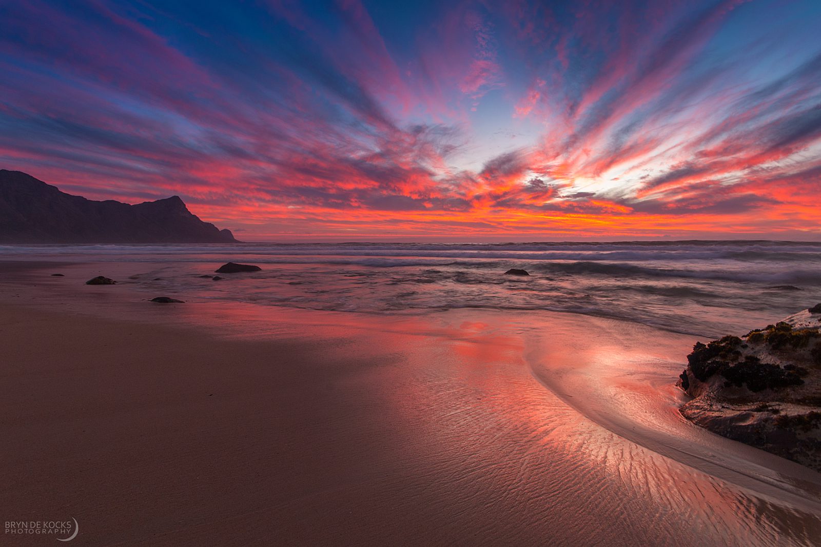
Sunsets have the unique ability to combine different colours in ways our imagination cannot even capture. Colours range from cool, blue hues during low-level cloud events to bright reds, soft pinks, and stunning gradients that form from a mix of these colors.
Contrast
Contrast isn’t always necessary, and sometimes the uniform softness that comes from a lack of contrast can make an image very appealing. But contrast can also be an extremely powerful element in any sunset.
Contrast is usually a result of different cloud layers which differ in altitude. Low-stratus clouds will often appear dark against a background of high-level cirrus, this can give an image immense depth.
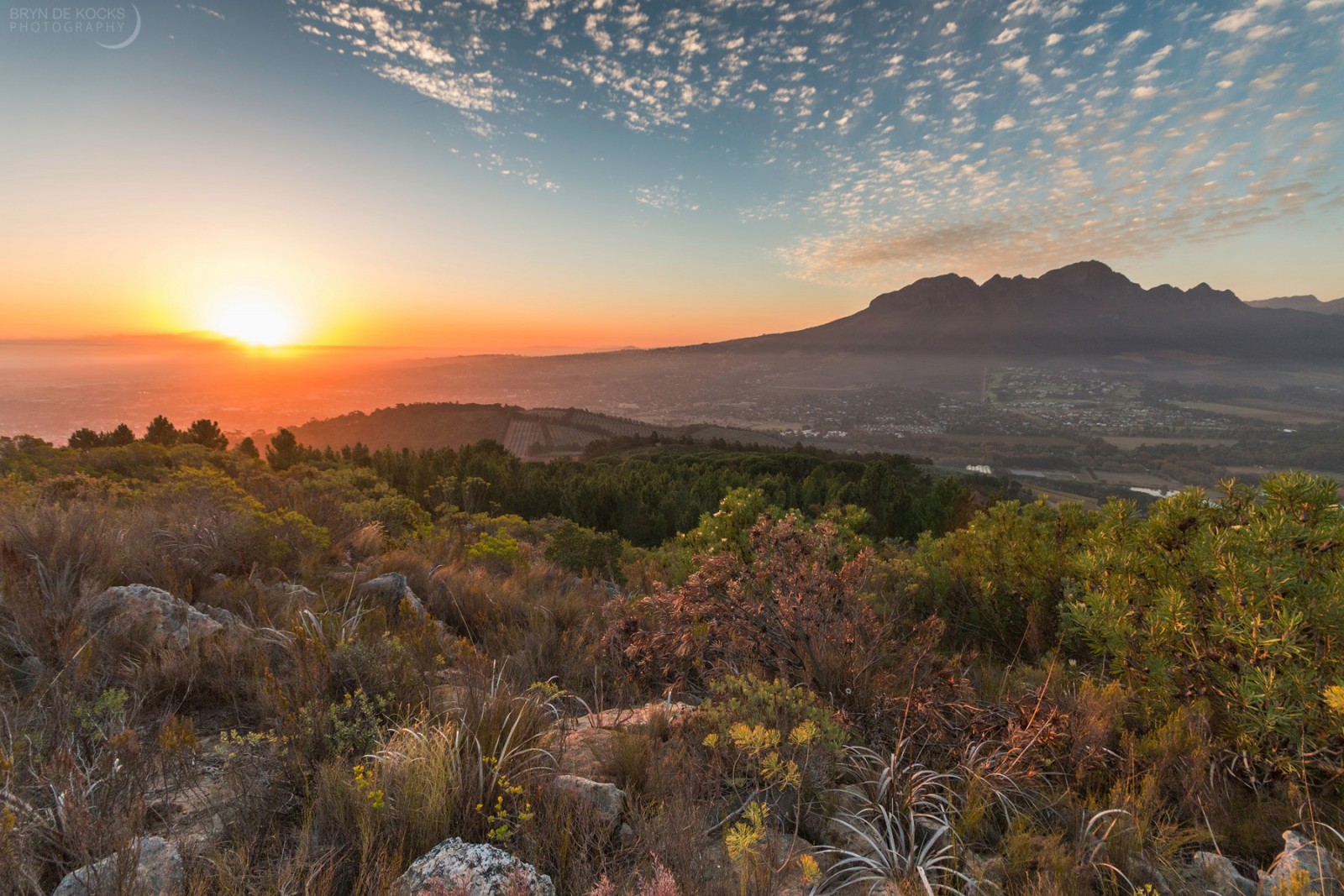
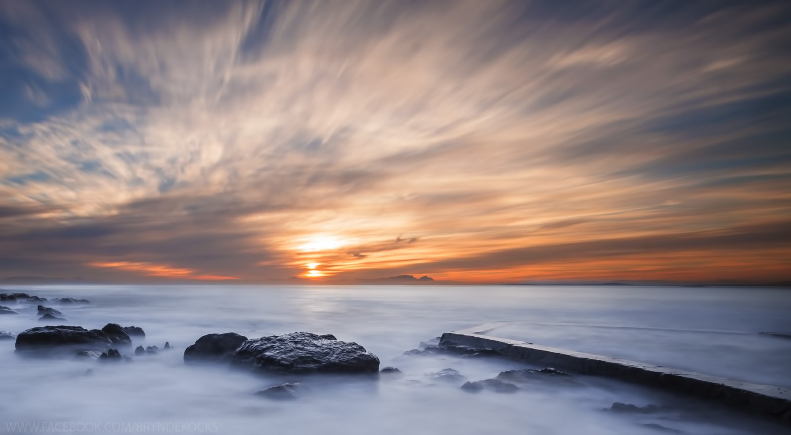
Gradients
The cool thing about gradients is that they don’t require the same complex cloud scenarios. Sometimes a cloudless sky can still produce an aesthetic gradient that sets the scene. Think about the classic African veld imagery. A clear sunset with a colour gradient (and maybe an Acacia Tree to the side of it.)
Leading Lines
A leading line takes the viewer’s eye from one area of the photo to another. In sunset photography, this can either be done using foreground elements or using clouds (wispy cirrus is good) to create these leading lines.
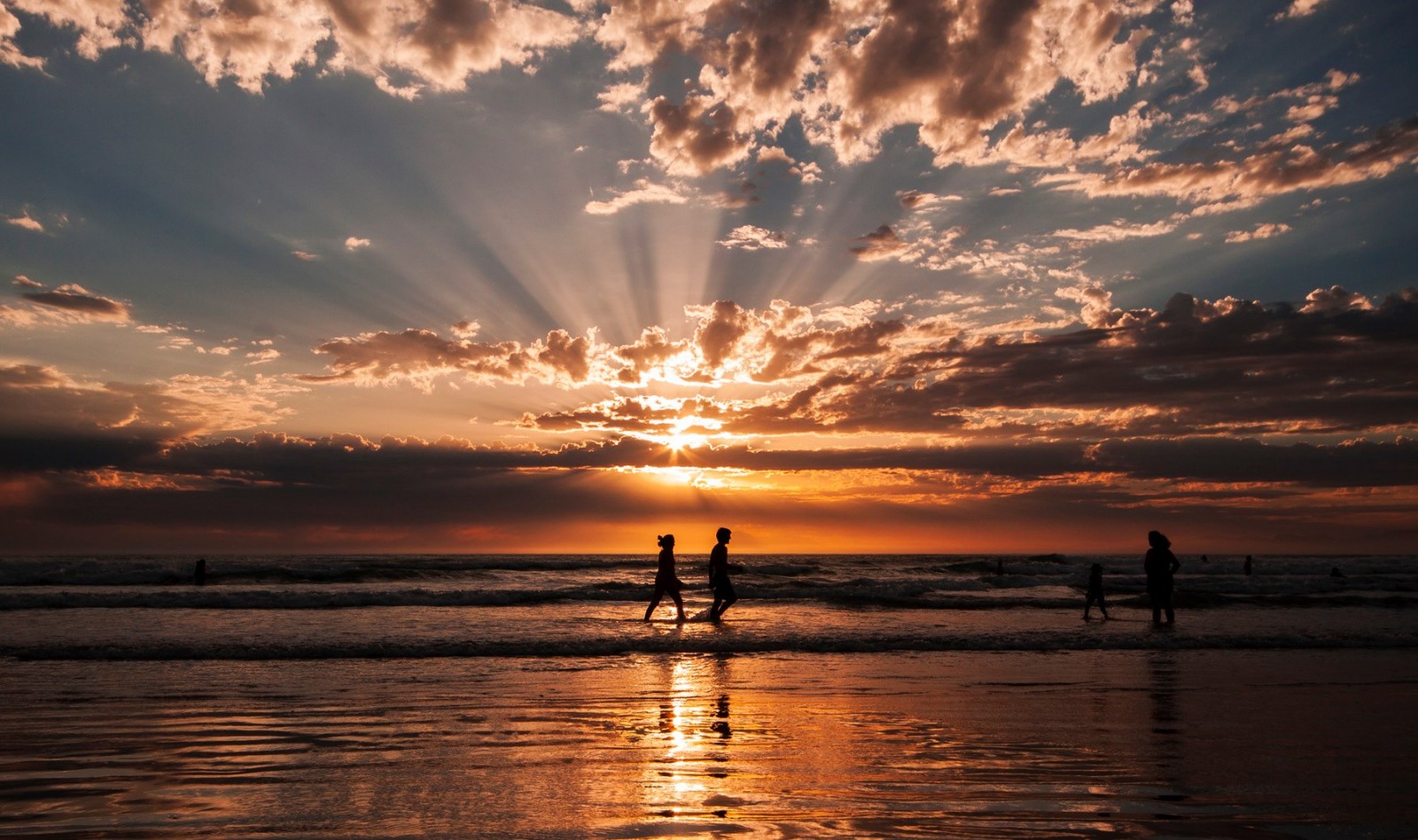
Foreground
The foreground may seem irrelevant when you’ve got a cracking sunset in front of you, but the foreground arguably has the most impact on your image. It’s how one can tell a skilled sunset photographer from an amateur.
A simple dark foreground just doesn’t do it! And there are a few ways to avoid it:
- Be conscious about your foreground choices before the sun sets.
- Compose primarily for your foreground and use the rule of thirds.
- Try to catch enough light in your foreground to bring out detail.
- In cases where the foreground is too dark, relative to the sky, use a graduated neutral density filter to lower the amount of light being let through in the sky portions of your image.
- If there’s no way to bring detail out of your foreground, be creative with silhouettes.
Composition
The rule of thirds has a strong presence in sunset and landscape photography. When composing your sunset shot, consider the position of elements in both the X and Y axes of your image. In other words be conscious of this rule not just in where you place your horizon, but also your foreground elements.
The Importance of Knowing Your Clouds
So what’s the biggest secret to landing the sunset shots you can be proud of? It’s understanding the clouds to gain an understanding of the sky’s potential and to position yourself accordingly.
By knowing your clouds and the wind direction, you can prepare for sunset hours ahead of time, especially if you use this information with satellite imagery. Here are the most common cloud types and how they influence sunsets.
Cirrus
Cirrus are high-level clouds (20,000 to 40,000 ft altitude) that can often be identified by their often wispy appearance. They frequently go golden in the late afternoon or early evening and are especially prevalent down here in Cape Town in the Autumn months.

One can predict the presence of cirrus by watching for cold fronts, they’ll often show up hours or a day before a cold front arrives and are often visible on satellite.
Depending on how the sky is clearing, cirrus can quickly fade to a dull grey – or be ignited into fiery red whisps. There’s always a bit of luck involved with these.
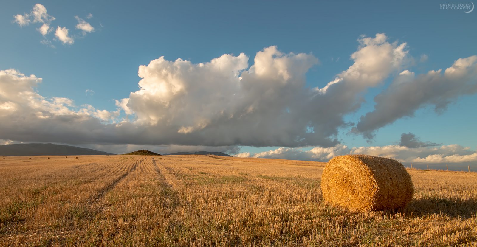
Cumulus
Cumulus is the classic fluffy, cotton-looking cloud. They are mid-level clouds and are significantly lower in the sky than cirrus. Cumulus are often a result of convection, but they don’t always make the most striking sunsets.
That doesn’t mean they can’t though – in the right conditions cumulus can look marvelous, as their denser structure causes the edges to glow. Since they are lower in the sky, they tend to get colouful a bit quicker than cirrus.
The secret here is to have enough cumulus in your field of view, while also not having distant clouds blocking the sun from reaching the base of the clouds closer to where you’re shooting. A clear line of sight from the sun will give a better result.
Cumulus can pair well with cirrus on days where different cloud layers exist – with the cirrus creating a backdrop with the cumulus standing out in front of it, often looking deep and immersive.
Altocumulus
Altocumulus are small fluffy little clouds that stand out because of their sheer numbers. Altocumulus are typically patches of clouds that look almost uniform in how they cover the sky. Altocumulus events are often related to upper-level troughs (low pressure extending down from the north, here in South Africa).
These clouds offer awesome sunsets and they often coincide with higher-level cirrus to create even more extraordinary views with additional depth. Altocumulus will often behave similarly to cumulus in the early stages of the sunset, with golden linings. But at the peak of sunset, they can change into rich red and orange tones.
When shooting altocumulus, think about the patterns they create in the sky. Unlike a lot of clouds, these usually cover a large area and can create unique patterns in the sky depending on the mid-level winds.
Towering Cumulus
When there’s enough instability and moisture around, a regular cumulus cloud can evolve into a towering cumulus, a term used to describe clouds that tower up into large cotton-looking clouds, quite different from the iconic landscape cloud, the cumulus.
These towering cumulus can reach incredibly high altitudes, and once they breech the troposphere and turn into cirrus at the tops, these clouds become cumulonimbus.
Towering cumulus isn’t usually great for sunsets, though some opportunities exist when observing them to the east. I’ve found these clouds consistently look better when they aren’t in the same direction as the sunset.
Sometimes the base may illuminate with red, but these cases are less common. Where these clouds look best is actually during late afternoon or early morning, an hour or so before sunset.
Cumulonimbus
Cumulonimbus are rare down here in the Western Cape but are a daily sight up country during the summer months. They are the classic, iconic thunderstorm clouds. When a cumulonimbus builds, it starts off as a towering cumulus – and then with enough instability and moisture content, it can extend up to heights like that of cirrus. This creates what’s called an anvil, because of how the cloud resembles a blacksmith anvil.
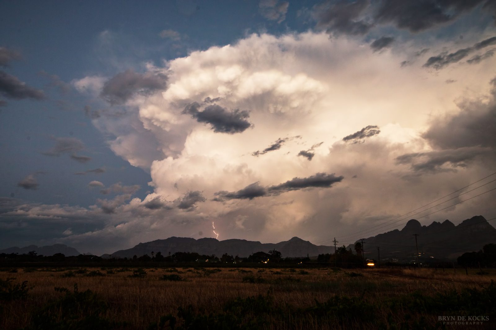
A cumulonimbus therefore is a single cloud that can be illuminated in multiple ways. The mid-level moisture lightens up like a cumulus, while the top of the anvil is often closer to the cirrus clouds in how it lights up.
I’ve found these clouds are almost always the best shot facing east. Their sheer magnitude often fails to light up in the direction of the sunset, but this may also just be in my location, where most CBs form to the east.
Oftentimes the best sunsets will occur near the base of the cloud, which can even form the unique and memorable Mammatus cloud.
Asperatus
Asperatus is one of the newest clouds to be classified and is much rarer than your typical sights. These unique clouds look like defined ripples in the sky and they indicate unstable atmospheric conditions.

If you’re lucky enough to encounter an Asperatus sunset, you can get lucky to the west or the east – but it’s far from guaranteed. The key here is going to be the clearing sky from the west, as Asperatus is often associated with lots of dense clouds that can just darken the sky as the sun sets.
Stratus
Stratus are low-level clouds that most photographers want to avoid unless one’s going for a moody scene. These clouds will block out most of the sunlight unless one gets above them. And this is where stratus can become awesome.
Long exposure shots in combination with an upper view of Stratus can create dramatic sunsets with lots of motion in them. A common location for shooting these clouds is at the top of Signal Hill in Cape Town, as stratus and stratocumulus often push into the bay.
Lenticular
Chances are that you’ve seen lenticular before. They’re the clouds that look like UFOs and are much more common in mountainous areas. I live in the Helderberg basin and we often get lenticular clouds going into autumn.

Lenticular is one of the few clouds that can be photographed just about any time of day and still look striking, especially if one plays the UFO angle and experiments with the foreground or horizon.
During sunsets, lenticulars are typically best viewed to the east and often don’t light up as well when to the west. They can give cracker sunset views with bright orange hues midway through the sunset, and even sometimes create pink or red hues.
Mammatus
A very rare cloud, especially when properly formed. Mammatus get their name from their breast-like appearance. These clouds droop down out of the sky and can be subtle and nearly indistinguishable from light Asperatus formations, however, they can also do some unbelievable things when they are tightly clustered and span a large area.

Mammatus look great any time of day, but when the sun sets it’s possible to have other-worldly scenes. Regardless of where you are in South Africa, these are rare, but you’ve got better chances in thunderstorm-rich areas like the northern half of the country. Down here in the Cape, we got 10 to 20 years between truly significant Mammatus events.
Nimbostratus
This isn’t a cloud type you’re likely to want for sunset. It is a dense low-level, typically cold weather cloud that’s associated with winter storms and snow. Even with a clear western horizon, these clouds don’t typically illuminate, instead just turning very dark, very early on into the sunset.
Cirrostratus
Cirrostratus are high-level clouds that resemble cirrus, but instead of being wispy – these clouds are veil-like, creating a milky layer in the sky. A good way to identify Cirrostratus is by looking at the sun, as these clouds will regularly create a halo around the sun.
When it comes to sunsets, cirrostratus frequently turns gold, and depending on the setup, can often peak earlier on in the sunset. But don’t sleep on the potential for a late bloom. I’ve often thought the peak sunset was over during Cirrostratus events only to look back in regret on my way back to the car.
Clear In The West, Is When Sunsets Are Best
One of the easiest ways to gauge the potential of a good sunset is to look for times when there is significant cloud presence (especially high-level clouds) but clearing in the west. While there are exceptions, clouds in the west most often block light from reaching the skies above the photographer.
Think of it like shining a flashlight at the wall and then placing your hand in front of it. Low clouds on the horizon can also block the rays of light from hitting the cloud bases and lighting up. These sunsets tend to be dull and moody, which is great if you’re going for that – but for most sunset photographers, there’s a desire for the biggest and brightest.
Don’t Give Up Too Quickly
I can’t tell you how many times I forgot this rule for sunset photography. I’ll assume the show’s over, head back to my car only to look back and see a scene that was ten-fold what I was just shooting. Oftentimes this intense burst of light only lasts for a few minutes, so you’re unlikely to make it back to your foreground composition before it starts to fade, which can also happen fast.
This late bloom typically occurs with high-level clouds like cirrus and cirrostratus. That’s because at that time of the evening, the sun has already set and its rays are primarily facing upward at a steeper angle, which better illuminates these high-level clouds.
Camera Settings For Sunset Photography
I strongly recommend using your manual camera settings (assuming you’re shooting on a camera and not a cellphone).
Shutter Speed: If you’re on a tripod, you don’t need to worry about motion blur, which lets you get creative with your motion, using long exposure. If you’re shooting handheld, I’d recommend staying above 1/80 of a second to reduce camera shake.
ISO: Lower ISO is almost always better for landscape photography in general, but if the lighting is too low and you’re shooting handheld, you may need to increase to 200, but I wouldn’t go higher than that. Modern noise reduction software can do great work at compensating.
Aperture: For landscapes, you want a higher aperture than normal, around F9 to F11 is a common range to aim for. Just keep in mind that a higher aperture will reduce light and require a higher ISO or longer shutter speed.
Lenses: Whatever works for your scene, but sunsets are often best captured in the wide-angle range where you can truly capture the magnitude of the sky and relation to the foreground.
Tiers and Rarities Of Sunsets
No, I’m not joking. Some of us weather nerds have specific mental rankings as to how well a sunset performs. There are a bunch of checkboxes at play each time the sun sets. Some days you roll a 1 (in fact, most days) but just every now and then you roll a 6 and come away from the experience with a sense of accomplishment. The most honest and deep accomplishment one can have is the process of experiencing nature doing something special, completely outside of our control.
So what are these checkboxes you may wonder? While it’s different for every person, these are what I look for in an S-Tier sunset:
- Is there a good variety of cloud layers?
- How good was my foreground during the experience? (a sunset at the beach with wet sands reflecting the sky will always be more memorable than a sunset in the Checkers parking lot)
- Were there rare colours present? (Orange and yellow hues are common, but occasionally some incredible tones can appear)
- Was there another dynamic weather event present (tornado, fog, lightning, hail, rainbow, etc)?
- How good is the atmospheric clarity/viewing distance?
- How vibrant/bright do the colours get?